Erin Cavazos

Erin Cavazos

Erin Cavazos

Erin Cavazos

Erin Cavazos joined the River Authority in 2014 as an engineer working on the FEMA Flood Mapping and Risk MAP projects, Watershed Masterplans, and Region L. In 2017 she became a Senior Engineer, supervising the team working on the H&H models, Floodplain Mapping Updates, Risk MAP, Flood Mitigation Planning, Water Resource initiatives, and Nature Based solutions. As the Ecological Engineering Manager, Erin leads teams focused on Community Planning, Predictive Modeling, Water Quality Modeling, Water Resources, and Floodplain Management.

Erin obtained her BSE in Civil Engineering from Tulane University and her MSc in Water Science, Policy, and Management from Oxford University. She served in the Peace Corps in the Dominican Republic and is fluent in Spanish. She is a licensed Professional Engineer and a Certified Floodplain Manager. Erin also serves on the National Association of Flood and Stormwater Management Agencies as a co-chair for the Floodplain Management Committee. In her spare time, Erin enjoys hiking, reading, and raising her two handsome boys.

Alerts

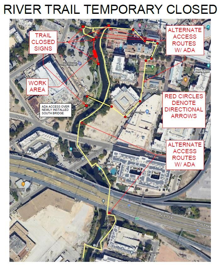
Trail Closure: Museum Reach at Pearl

* Trail temporarily closed from 2/3/2025 until 4/25/2025.
* For southbound pedestrian traffic, please exit the river and utilize the Hotel Emma bridge to gain access to the east side river trail. Access to the east side river trail via the elevator or stairs.
* For northbound pedestrian traffic, please exit the river trail at the south bridge to gain access to the east side river trail. Continue north through Pearl towards Hotel Emma. The west & east side river trail accessible via the Hotel Emma bridge.

North Bridge West Landing & Stairs Trail Closure Map


Goliad Paddling Trail Alert

NOTICE: HWY 59 Landing Site Closed

Due to TxDOT construction on the HWY 59 Bridge, the HWY 59 landing site is closed until further notice. However, the Goliad Paddling Trail remains open, and paddlers can still access the river at the Riverdale, Ferry Street, and Goliad State Park landings.

Please plan accordingly and check back for updates.

SASPAMCO Paddling Trail Temporarily Closed

Staff have removed two large log jams just downstream of Helton Nature Park, keeping the southern portion of the SASPAMCO Paddling Trail temporarily closed. Staff are working to contact adjacent landowners to support a land-based removal solution.

SASPAMCO Paddling Trail

The SASPAMCO paddling trail is open from River Crossing Park to Helton Nature Park.
*Please Note: Paddling Trail from Helton Nature Park to HWY 97 is still closed due to blockages. 

River Reach Newsletter and Blog Signup

River Reach is offered as a printed, physical mailing to your residence or business. The Blog is a weekly electronic email with news and updates in order to be more environmentally conscious. Please fill out the form below and indicate your preferred method of delivery.

By submitting this form, you are consenting to receive marketing materials from: San Antonio River Authority, 100 East Guenther St., San Antonio, TX, 78204, US. You can revoke your consent to receive emails at any time by using the SafeUnsubscribe® link, found at the bottom of every email. Emails are serviced by Constant Contact. This site is protected by reCAPTCHA and the Google Privacy Policy and Terms of Service apply.