USGS Leon Creek Sediment Analysis

USGS Leon Creek Sediment Analysis

The Texas Department of Health has issued a fish consumption advisory stating that the consumption of fish from Leon Creek may pose a threat to human health due to polychlorinated biphenyls (PCBs). This advisory extends from Old U.S. Highway 90 Bridge downstream to the Loop 410 bridge in South Bexar County. Previous sediment sampling confirms the presence of trace elements, pesticides and PCBs in Lower Leon Creek at and below the former Kelly Air Force Base (AFB). It is unclear if the contaminants originate from the AFB or from the watershed upstream of the AFB. This project conducted both streambed and suspended sediment sampling and analysis for contaminants with special focus on PCBs to determine source of contaminants.

See the assessment of selected sediment-associated contaminants in samples collected in Bexar County here

Project Details:

Share:

Facebook
Twitter
LinkedIn
Email

Related Projects

This project will assess the long-term space needs of the River Authority and evaluate various options regarding new building designs for the property located at…
This project will begin design and construction on Mann’s Crossing Park on the Medina River, Hendrick Arnold Park (Straus medina), Trueheart Ranch, and Espada Park.…
The San Antonio River Authority is collaborating with the US Army Corps of Engineers to restore portions of the Westside Creeks, including portions of San…

Alerts

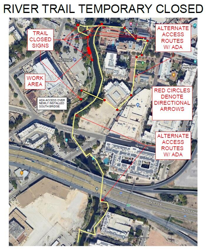
Trail Closure: Museum Reach Trail

Please be advised that the Museum Reach Trail at the Pearl South Bridge will be closed from Thursday, December 19, 2024, through Friday, December 20, 2024, until close of business.

This closure affects the west bank of the river between Newell Street and Myrtle Street due to construction on the trail. Barricades and signage are in place to indicate the closure and provide alternative routes.

We apologize for the inconvenience and appreciate your understanding and cooperation during this period.

Note: Please exercise caution and follow all posted signage and barricades in the area.

Stem Density Efforts

Please be advised that trails near the Confluence Park and Conception Park area will be temporarily closed due to ongoing Stem Density efforts. We appreciate your cooperation and ask that you remain mindful of workers and closures when in the vicinity. Thank you for your patience as we work to improve our natural spaces!


SASPAMCO Paddling Trail Temporarily Closed

Staff have removed two large log jams just downstream of Helton Nature Park, keeping the southern portion of the SASPAMCO Paddling Trail temporarily closed. Staff are working to contact adjacent landowners to support a land-based removal solution.

SASPAMCO Paddling Trail

The SASPAMCO paddling trail is open from River Crossing Park to Helton Nature Park.
*Please Note: Paddling Trail from Helton Nature Park to HWY 97 is still closed due to blockages. 

River Reach Newsletter and Blog Signup

River Reach is offered as a printed, physical mailing to your residence or business. The Blog is a weekly electronic email with news and updates in order to be more environmentally conscious. Please fill out the form below and indicate your preferred method of delivery.

By submitting this form, you are consenting to receive marketing materials from: San Antonio River Authority, 100 East Guenther St., San Antonio, TX, 78204, US. You can revoke your consent to receive emails at any time by using the SafeUnsubscribe® link, found at the bottom of every email. Emails are serviced by Constant Contact. This site is protected by reCAPTCHA and the Google Privacy Policy and Terms of Service apply.