Última actualización el 31 de marzo de 2023
La Autoridad del Río San Antonio (Autoridad del Río) depende de científicos de la calidad del agua, biólogos acuáticos, científicos de monitoreo de cuencas e investigadores ambientales para recopilar y analizar datos que identifiquen condiciones positivas y negativas en el Río San Antonio como parte del compromiso de la agencia para seguro, limpio, agradable arroyos y ríos.
Estos datos están disponibles para el público y la Autoridad del Río ha desarrollado herramientas como nuestra nueva Panel de calidad del agua que ayudan a presentar los datos de una manera informativa y fácil de usar para ilustrar la salud de los arroyos y ríos dentro de Cuenca del río San Antonio. ¡Sigue leyendo mientras compartimos más información sobre esta nueva herramienta y destacamos características importantes!
¿Qué datos ilustra el Panel de Calidad del Agua?
Biólogos acuáticos de River Authority y monitoreo de cuencas hidrográficas científicos recolectar muestras de agua superficial, aguas pluviales y sedimentos de toda la cuenca del río San Antonio. Estas muestras se envían al Laboratorio Ambiental de la Autoridad del Río, donde los científicos generan datos sobre la calidad del agua. El Panel de calidad del agua es una serie de informes de datos de las estaciones de monitoreo de la calidad del agua de la Autoridad del Río que ayudan a contar la historia de la calidad del agua del río. Toma conceptos científicos y los simplifica usando ilustraciones y explicaciones con ejemplos del mundo real para que sea fácil de entender.
Pero lo más importante es que la información se presenta de una manera que motiva a quienes la utilizan a actuar e involucrarse para ayudar a mejorar la salud del río.
Características del panel de control de calidad del agua
¡Vea algunas de las características principales del panel que lo ayudarán mientras explora esta nueva herramienta!
- La página principal le permite limitar la cantidad de estaciones de monitoreo en el mapa a través de diferentes filtros, como por condado o cuenca. Al resaltar capas relacionadas, permite al usuario comprender la relación entre la cuenca y los condados.
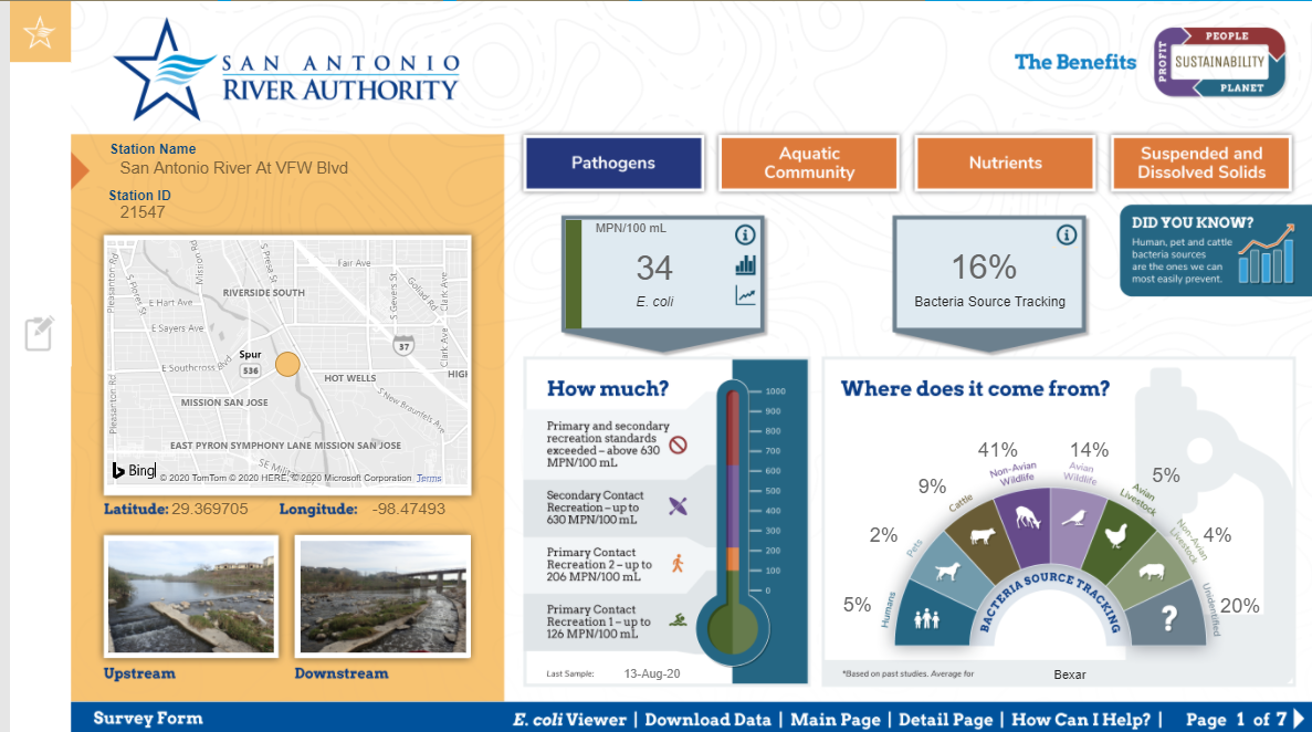
- Los datos que se muestran para cada parámetro tienen un diseño simple con un código de color lateral fácil de entender y potentes información sobre herramientas para enriquecer el contexto de estas historias. Las descripciones y gráficos detallados dan una idea del estado actual e histórico de estas estaciones.
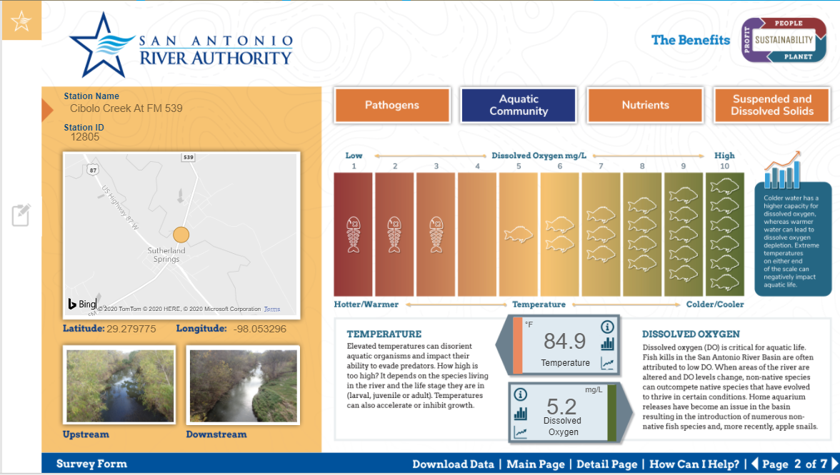
- Algunas métricas son indicadores de la escorrentía de aguas pluviales, mientras que otras se relacionan con la capacidad de una vía fluvial para sustentar poblaciones de peces saludables. ¡Consulta la pestaña de comunidad acuática para ver la capacidad de tu vía fluvial local para producir tu próximo pez trofeo!
¡Esperamos que disfrute aprendiendo más sobre la salud de los arroyos y ríos del área explorando esta herramienta! Por favor completa esto encuesta y cuéntanos tu experiencia. También puede unirse a nosotros en nuestros esfuerzos para proteger y preservar los recursos naturales de la cuenca del río San Antonio al mostrando tu orgullo por el río y compartir en nuestros canales de redes sociales siguiendo a @sanantonioriver.