Última actualización el 30 de enero de 2024
Esta serie brinda a los lectores la oportunidad de conocer las ideas y experiencias únicas de la Junta Directiva de la Autoridad del Río San Antonio (Autoridad del Río) y su conexión personal con el Río San Antonio con la esperanza de inspirar la administración de los arroyos y ríos del área.
James Fuller, MD, Condado de Goliad
El Dr. Fuller es un cirujano cardiotorácico jubilado. Ha participado activamente en temas relacionados con la San Antonio Cuenca del río durante muchos años. Actualmente, trabaja en el Distrito de Conservación de Suelos y Agua de Goliad y participa en proyectos de conservación en curso con el Departamento de Parques y Vida Silvestre de Texas, Pesca y Vida Silvestre de EE. UU., Ducks Unlimited y Guadalupe-Blanco River Trust. Ha sido miembro de la junta de River Authority en representación del condado de Goliad desde 2013. Fue reelegido miembro de la junta en 2019 y su mandato actual expira en 2025.
¿Qué valor aporta la Autoridad del Río San Antonio a la comunidad?
El punto de acceso a Riverdale en Goliad Paddling Trail. Crédito de la foto: Autoridad del Río San Antonio
El valor de River Authority para la comunidad es inmenso y de gran alcance. Es más evidente en sus relaciones con los gobiernos de ciudades y condados, escuelas, distritos de aguas subterráneas y organizaciones sin fines de lucro como la San Antonio River Foundation, San Antonio Bay Partnership, Canoe Trail Goliad y Brackenridge Park Conservancy.
El Alcance del museo y Alcance de la misión como parte de la Proyecto de mejoras del río San Antonio, Parque Cultural San Pedro Creek, Proyecto de restauración de Westside Creeksy parques de la Cuenca Sur como Autopista Escondido Creek en el condado de Karnes y Parque del río Branch en Goliad han sido posibles gracias a esfuerzos de colaboración. Se han completado muchos kilómetros de senderos para caminar y andar en bicicleta, y se están realizando muchas más mejoras. Además, ahora existen puntos de acceso fácil y seguro para canoas y kayaks en toda la cuenca. El punto de acceso más reciente es el acceso a Riverdale en Goliad, que amplió el Sendero para remar Goliad desde aproximadamente 7 millas de longitud hasta ahora más de 19 millas. Esta mejora agregó 12 millas para flotar en la parte inferior del río, que también incluye los puntos de acceso originales en la autopista 59, Ferry St. y el Parque Estatal Goliad.
Conectar personas, tierras y comunidades: ese es el valor fundamental de la Autoridad del Río San Antonio.
¿Cómo podemos garantizar que el río San Antonio se preserve para las generaciones futuras?
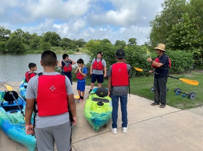
Los estudiantes de South San ISD se preparan para remar en el río San Antonio en Acequia Park Crédito de la foto: Autoridad del Río San Antonio
El autor y activista ambiental Edward Abbey dijo que para proteger y preservar un lugar, primero hay que “amarlo”. Para amarlo hay que conocerlo, y eso no puede suceder desde una carretera, a cualquier velocidad. En mis viajes de Goliad a San Antonio para reuniones, cruzo el río tres veces, yendo y viniendo, pero nunca veo realmente nuestro río. Es por eso que senderos y puntos de acceso para remar son vitales para involucrarse de manera significativa con el río.
También es esencial faFacilitar oportunidades para que los jóvenes vean el río de cerca. Para lograr este objetivo, la Autoridad del Río Equipo de Educación y Compromiso hace todo lo posible para informar a estudiantes y adultos sobre las complejas interacciones en nuestra cuenca fluvial altamente desarrollada.
¿Cuál es la mejor manera de interactuar con el río San Antonio?
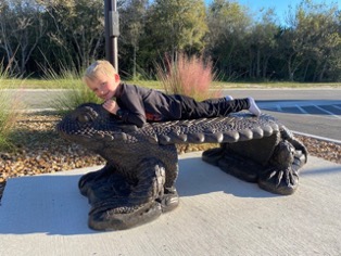
Gra del Dr. Fullerndson disfruta de la escultura del lagarto cornudo en Escondido Creek Parkway en el condado de Karnes. Crédito de la foto: Dr. James Fuller
La interacción con el río es posible de innumerables formas. Visitar uno de los parques, andar en bicicleta, nadar, pasear en bote, pescar, observar aves, identificar plantas nativas, tomar fotografías o jugar golf de disco son solo algunas de las formas de participar. ¡O podrías montar en el lagarto cornudo en Escondido Creek Parkway! Personalmente, me gusta ver el amanecer todas las mañanas en mi propiedad en el distrito histórico del Valle del Río San Antonio. Temprano en la mañana, veo y escucho todo tipo de vida silvestre, incluidos coyotes, búhos, venados e incluso linces.
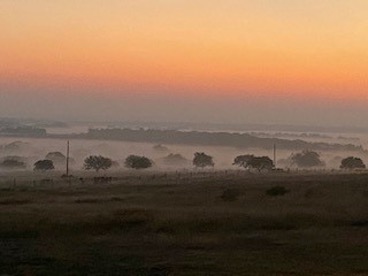
Amanecer en el Distrito Histórico Rural del Valle del Río San Antonio. Crédito del vídeo: Dr. James Fuller
Nombra un hecho interesante sobre la cuenca del río San Antonio que la mayoría de la gente tal vez no conozca.
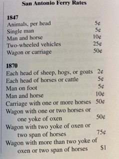
Tarifas de ferry de San Antonio alrededor de 1900. Crédito de la foto: Louise O'Connor's “Cuentos del fondo del río San'tone”
En el Cuenca Sur, que en la Autoridad del Río generalmente consideramos como los condados de Wilson, Karnes y Goliad y más allá a medida que el río fluye hacia la costa del Golfo, el río San Antonio se conoce desde hace mucho tiempo como San'tone. Los primeros pobladores de esta zona se referían a su hogar como “las curvas” por la forma en que el río serpentea hacia adelante y hacia atrás a medida que avanza hacia la Bahía de San Antonio. Desde 1840 hasta aproximadamente 1900, un ferry era la única forma de cruzar el río San Antonio. Hubo al menos nueve transbordadores operativos en la cuenca baja del río San Antonio durante este período y se desarrollaron asentamientos en la mayoría de estos sitios de cruce de ríos. El acceso a Ferry Street cerca de Branch River Park en Goliad era un cruce bullicioso ya que el río era más ancho y profundo en aquellos días y las orillas no eran tan empinadas. Hay una gran historia en Goliad, en gran parte debido al río. Animo a todos a que visiten Goliad para ver, de primera mano, esta histórica comunidad de Texas.