Last Updated on March 31, 2023
As part of our commitment to safe, clean, enjoyable creeks and rivers, the San Antonio River Authority (River Authority) has created the San Antonio River Basin Report Card. Learn more about this inaugural river basin report card and how each person can help improve the health of the river basin!
Why did the River Authority create the San Antonio River Basin Report Card?
The development of the San Antonio River Basin Report Card grew from the River Authority’s drive to harmonize the needs of people and nature through our stewardship of rivers and land. The main purpose of this new river basin report card is to shine a light on the healthy and the unhealthy aspects of the basin in order to educate the public and serve as a catalyst for community discussions that lead to individual choices and public policy decisions, actions, and investments that support a sustainable San Antonio River Basin.
It is important to note, while the work of the River Authority can and does influence some of the indicators in this river basin report card, this report card is not intended to “grade” the River Authority. The River Authority has a separate set of metrics related directly to its annual strategic plan to determine how progress is being made on the projects and efforts funded in its annual budget. The River Authority’s annual budget, which contains its strategic plan, can be seen here.
The expert engineers, scientists, technical, and specialized staff of the River Authority exercised their best professional judgment to determine the most meaningful list of indicators for this inaugural river basin report card. To help tell the very diverse and complicated story of the San Antonio River Basin in a simple, easy-to-understand way, the River Authority selected 12 indicators that were based on observations of basin health and comprised of accessible and defensible data which could be easily explained to the laymen public. Where feasible, indicators use standards or guidelines established by State or Federal regulatory agencies, such as the Texas Commission on Environmental Quality and the Environmental Protection Agency. The River Authority’s mission of being committed to safe, clean, enjoyable creeks and rivers was also a driver in the indicator selection process.
How is the San Antonio River Basin Report Card structured?
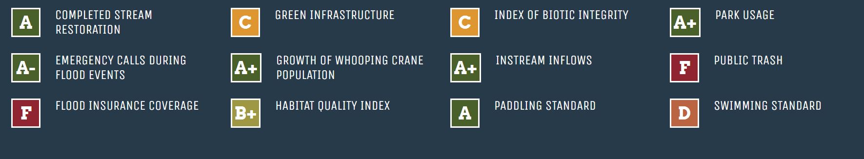
The 12 metrics being graded in the San Antonio River Basin Report Card include a diverse set of measurements with each scoring a different type of unit. Results of each metric are standardized against a common scale of 0-100 to overcome difficulties associated with comparing indicators with different measurement scales and units. Sometimes this conversion is straight-forward; sometimes it can be challenging.
For this river basin report card, the standard one-hundred-point scale is divided into five equal parts where an “A” equates to 100-80 (Excellent); B is 79.9-60 (Good); C is 59.9-40 (Moderate); D is 39.9-20 (Poor); and an F is 19.9-0 (Failing). The reason for the broader spread in scores is that this scale is more sensitive to, and reflective of, changes in river basin conditions. The larger spread in scores also allows for an easier way to include a plus and minus scale where the upper 5 points of the 20-point range is a plus score and the lower 5 points of the 20-point range is a minus score. The “F” score, however, does not have a plus or minus.
Some of the indicators in this basin report card are essentially a trend analysis scoring Fiscal Year 2019-20 (July 1, 2019 through June 30, 2020) data against an average of up to five fiscal years of previous data. It is possible for these trend analysis metrics to have a final numeric score above 100 or below 0. If a final indicator score is above 100, the grade will be shown as an “A+” on the report card dashboard, and a final score below 0 will be shown as a “F” grade on the dashboard.
The final numeric scores of all 12 indicators will be averaged to produce the overall basin grade. For this inaugural San Antonio River Basin Report Card, the overall basin grade is 66.2, which equates to a “B” letter grade.
How can I get involved?

The River Authority intends to issue future river basin report cards each September to correspond with World Rivers Day. With each annual basin report card, the grades for the indicators will show trends that will be highlighted over time. Together, we can be river proud by achieving and maintaining good grades and focusing our collective community attention on improving areas that are scoring low.
We invite you to see the full report card and learn more about the indicators, including what you can do to help next year’s grade improve!