River Authority Releases Basin Report Card

Written by:

Posted on:

Categories:

Share:

Facebook
Twitter
LinkedIn
Email

Get The Latest:

Join our print or digital newsletter to be informed about the agency’s many projects and other news.

SAN ANTONIOThe San Antonio River Authority (River Authority) announced that it has developed a San Antonio Basin Report Card as part of the agency’s commitment to safe, clean and enjoyable creeks and rivers. The development of the San Antonio River Basin Report Card grew from the River Authority’s drive to harmonize the needs of people and nature through our stewardship of rivers and land. The public can view the report card on the agency’s website where they will see the overall grade for the basin as well as a breakdown of the indicators used in the report card.

“Our staff conducted extensive research to learn from the best management practices from around the world when developing our basin report card,” said River Authority Interim General Manager Steve Graham. “We hope that this tool serves as a motivator for the implementation of positive actions that result in improvements to the health of the San Antonio River Basin.”

The main purpose of the San Antonio River Basin Report Card is to shine a light on the current conditions of the health of the river basin and serve as a catalyst for community discussions. Through engagement and education, the River Authority hopes to empower constituents to make informed decisions on their subsequent actions, future public policy, and investments that support a sustainable San Antonio River Basin. The River Authority selected twelve indicators that were based on observations of basin health and comprised of verifiable data points. The 12 indicators were each given a letter grade and the grades were averaged together for overall basin grade. The data is easy to understand and explained using common language for a user-friendly experience.

The River Authority plans to release the Basin Report Card on an annual basis to coincide with World Rivers Day which is celebrated the last Sunday in September.

To view the San Antonio River Basin Report Card and to learn more about the River Authority’s sustainability efforts and ways to get involved, visit sariverauthority.org.

Related Articles

Alerts

Museum Reach Maintenance Alert

Intermittent trail closures next week near I-35 overpasses by Newell Ave.
Trail maintenance will take place Monday, April 21 through Wednesday, April 23, from 8:00 AM – 5:00 PM (Mon-Tues) and 8:00 AM – 12:00 PM (Wed).
Closures will rotate between the east and west bank trails under I-35 at the Newell Ave. access point. Crews will reopen the trail segments when not actively working.

♿️ Alternate ADA-accessible routes are available:

If west bank is closed ➡️ use east bank via Camden St.
If east bank is closed ➡️ use west bank via Camden St.

Thank you for your patience as we complete this important maintenance work.

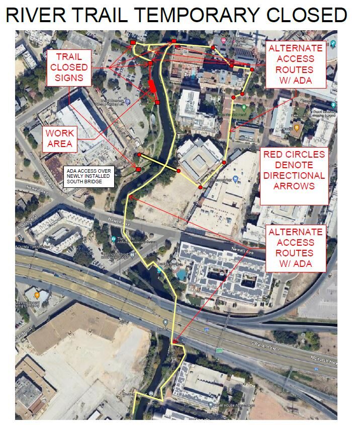
Trail Closure: Museum Reach at Pearl

* Trail temporarily closed from 2/3/2025 until 4/25/2025.
* For southbound pedestrian traffic, please exit the river and utilize the Hotel Emma bridge to gain access to the east side river trail. Access to the east side river trail via the elevator or stairs.
* For northbound pedestrian traffic, please exit the river trail at the south bridge to gain access to the east side river trail. Continue north through Pearl towards Hotel Emma. The west & east side river trail accessible via the Hotel Emma bridge.

North Bridge West Landing & Stairs Trail Closure Map


Goliad Paddling Trail Alert

NOTICE: HWY 59 Landing Site Closed

Due to TxDOT construction on the HWY 59 Bridge, the HWY 59 landing site is closed until further notice. However, the Goliad Paddling Trail remains open, and paddlers can still access the river at the Riverdale, Ferry Street, and Goliad State Park landings.

Please plan accordingly and check back for updates.

SASPAMCO Paddling Trail Temporarily Closed

Staff have removed two large log jams just downstream of Helton Nature Park, keeping the southern portion of the SASPAMCO Paddling Trail temporarily closed. Staff are working to contact adjacent landowners to support a land-based removal solution.

SASPAMCO Paddling Trail

The SASPAMCO paddling trail is open from River Crossing Park to Helton Nature Park.
*Please Note: Paddling Trail from Helton Nature Park to HWY 97 is still closed due to blockages. 

River Reach Newsletter and Blog Signup

River Reach is offered as a printed, physical mailing to your residence or business. The Blog is a weekly electronic email with news and updates in order to be more environmentally conscious. Please fill out the form below and indicate your preferred method of delivery.

By submitting this form, you are consenting to receive marketing materials from: San Antonio River Authority, 100 East Guenther St., San Antonio, TX, 78204, US. You can revoke your consent to receive emails at any time by using the SafeUnsubscribe® link, found at the bottom of every email. Emails are serviced by Constant Contact. This site is protected by reCAPTCHA and the Google Privacy Policy and Terms of Service apply.