River Authority to Begin Removal of Tree Stems Along Mission Reach Segment

Written by:

Posted on:

Categories:

Share:

Facebook
Twitter
LinkedIn
Email

Get The Latest:

Join our print or digital newsletter to be informed about the agency’s many projects and other news.

SAN ANTONIO – The San Antonio River Authority (River Authority) announced today that it will continue a process of removing select tree species along the San Antonio River Walk Mission Reach as part of the adaptive management process to maintain proper flood conveyance throughout the eight-mile stretch of ecosystem restoration project. The River Authority’s Watershed Park & Operations Department initiated the select tree removal process in September 2020. This select vegetation management process will begin again on October 18, 2021 and is expected to be completed within 30 days.

“During the stem density removal efforts, the River Authority aims to preserve the trees originally planted as part of the ecosystem restoration project and will focus on removing volunteer woody species that arrived since the opening of the project,” said River Authority Watershed Park & Operations Senior Manager Kristen Hansen. “With advanced modeling technology, we are able to determine the maximum number of stems allowed for any given area in the floodplain. The intent is to maintain high priority areas and allow as many trees to grow as possible without causing increased risk in the floodplain.”

Since the Mission Reach’s opening in 2013, the River Authority’s Watershed Park & Operations Department has performed ongoing maintenance as part of an adaptive management process to ensure the success and health of the ecosystem restoration and to maintain viewsheds of the river for enjoyment of the hike and bike trails all while providing proactive protection to the surrounding infrastructure to sustain the integrity of the river’s flood management function.

The River Authority’s Ecological Engineering Department conducted a study of the Mission Reach using the most current Federal Emergency Management Agency (FEMA) floodplain maps to identified high priority areas necessary for stem density removal. The study was completed with the goal of maximizing preservation of native trees while maintaining the flood conveyance requirements set forth by FEMA and the U.S. Army Corps of Engineers. The River Authority also coordinated with an avian expert to determine the ideal time to perform the vegetation management to minimize impacts to the various bird species that utilize the restored habitat. The effort will conclude by adding grassland vegetation to areas where trees are removed to assist with bank stabilization and continue the restoration of habitat along the river. 

For more information about the Mission Reach Ecosystem Restoration and Recreation Project and to learn more about the River Authority’s flood mitigation efforts, visit sariverauthority.org.

Related Articles

Alerts

SASPAMCO Paddling Trail Temporarily Closed

Staff have removed two large log jams just downstream of Helton Nature Park, keeping the southern portion of the SASPAMCO Paddling Trail temporarily closed. Staff are working to contact adjacent landowners to support a land-based removal solution.

Stem Density Efforts

Please be advised that trails near the Confluence Park and Conception Park area will be temporarily closed due to ongoing Stem Density efforts. We appreciate your cooperation and ask that you remain mindful of workers and closures when in the vicinity. Thank you for your patience as we work to improve our natural spaces!


Gas Spill

The San Antonio River Authority and the City of San Antonio are actively working to contain a recent gas spill in the Downtown River Walk Loop area, which occurred earlier today. The source of the spill is unknown but has stopped. At this time, no environmental impacts have been observed, and teams are implementing measures to fully contain and remove the substance. We will provide updates as the situation develops.

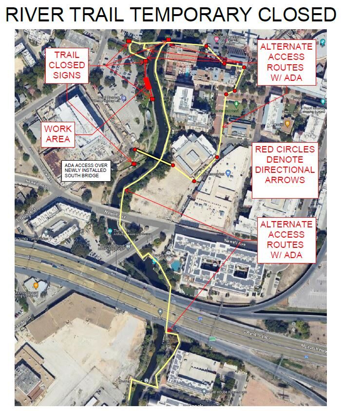
West Bank Trail Closure Notice

Due to the construction of a new trail and bridge, the West Bank of the trail between Schiller St. and Newell St. will be closed for the next couple of months. The East Bank will also be intermittently closed on Monday, November 4th, to install the bridge. Please use caution when navigating around this area. We apologize for any inconvenience.

Please refer to the map for reference. 

San Pedro Creek Culture Park

The restrooms at South Alamo will be temporarily closed for maintenance and repairs. We apologize for any inconvenience and appreciate your understanding. 

Acequia Trail Notice

The Acequia trail will have heavy traffic near MROC starting May 22nd until further notice. The SAWS Acequia project will be bringing in crews to work on the lift station site and across the street. There will have flaggers to stop traffic, please use caution. 

SASPAMCO Paddling Trail

The SASPAMCO paddling trail is open from River Crossing Park to Helton Nature Park.
*Please Note: Paddling Trail from Helton Nature Park to HWY 97 is still closed due to blockages. 

River Reach Newsletter and Blog Signup

River Reach is offered as a printed, physical mailing to your residence or business. The Blog is a weekly electronic email with news and updates in order to be more environmentally conscious. Please fill out the form below and indicate your preferred method of delivery.

By submitting this form, you are consenting to receive marketing materials from: San Antonio River Authority, 100 East Guenther St., San Antonio, TX, 78204, US. You can revoke your consent to receive emails at any time by using the SafeUnsubscribe® link, found at the bottom of every email. Emails are serviced by Constant Contact. This site is protected by reCAPTCHA and the Google Privacy Policy and Terms of Service apply.