
Last Updated on January 30, 2024
The “My River POV” series provides readers the opportunity to learn about the unique insight and experiences of the San Antonio River Authority (River Authority) staff and their personal connection to the San Antonio River in hopes of inspiring stewardship of area creeks and rivers.
Aarin Teague, PhD, PE, CFM, ENV SP, Ecological Engineering Manager
Aarin Teague is the Ecological Engineering Manager and has been with the River Authority since Fall 2012. She leads a team responsible for the River Authority’s development, utilization, and management of hydrologic and hydraulic, flood prediction, and water quality modeling. She is working to advance the River Authority’s Stream Restoration Program and natural resource protection efforts.
Have you ever sat in amazement at the quiet beauty of a stream or gazed in awe at the power of that stream after it rains? These moments of wonder have sparked a curiosity that pushes the Ecological Engineering team to ask a seemingly simple question: How does the San Antonio River work, and why do its streams behave as they do? Our team explores the San Antonio River Basin, attempting to understand the complex mix of natural and human-influenced processes that create its unique ecosystems.
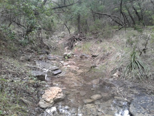
Headwaters of Leon Creek in the foothills of the Hill County
It is a privilege to walk, wade, or paddle through these everchanging streams and the land that feeds them. In the headwaters of the San Antonio River Basin, the tributaries and creeks of the Leon, Salado, and Medina are icons of the Hill Country. Steep, narrow, and rocky, this landscape is closer to what you might see in the foothills of mountains in New Mexico or Arizona than what you might expect near the Texas Gulf Coast. However, as these streams flow into the San Antonio River and meander towards the Gulf of Mexico, they become our classic streams and wetlands: ribbons of life throughout South Texas. This 240-mile transformation over 4,000 square miles crosses five different ecoregions to create the diverse and unique San Antonio River Basin. The watershed hosts over 70 species of fish, over 200 species of birds, and iconic wildlife such as the quiet American Alligators and the elusive but playful North American River Otter.
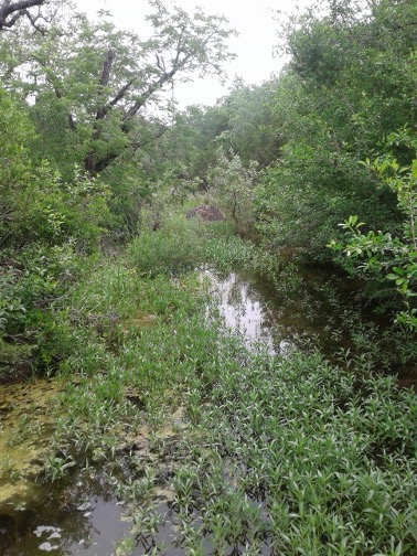
Wetland in the headwaters of Leon Creek
My team and I are privileged to see beautiful country and meet the people who care for it. Every field visit is an opportunity to see something new and intriguing. Imagine the wonder of stumbling into a hidden wetland in the headwaters of the Leon, emerging from the bedrock stream to form a pool of life surrounded by centuries of oaks and Texas walnut trees. Imagine the awe when seeing a whooping crane for the first time. Imagine the amazement at seeing the transformation of the Mission Reach into an urban oasis.

Stream near San Antonio Bay near the Texas Coast
Each day, our team works to conserve these natural resources and protect the people and communities that depend on them. The River Authority’s team of engineers, planners, and surveyors uses the elegance of math and science to find engineering solutions to problems threatening a safe, clean, and enjoyable San Antonio River Basin. It is rewarding to see the development of models that start with the painstaking collection of data. The River Authority survey team put in long hours in the field collecting topographic and land survey data. Our engineering team then uses this data to build complex mathematical models of our watersheds and streams. With great patience, the engineers develop these simulations to help visualize, predict, and understand how the stream will behave. Planners then work with the engineers to analyze these data products and use them in a myriad of applications. These include developing projects to restore riparian ecosystems, improve the water quality, and increase the resiliency of our community to flood risk.
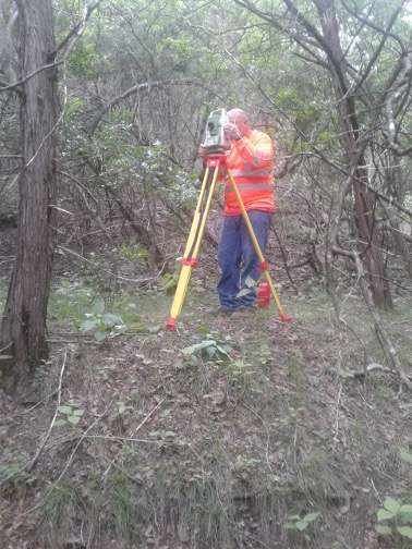
Matt McKeel, Surveyor in Training, collects field data to help develop stream models.
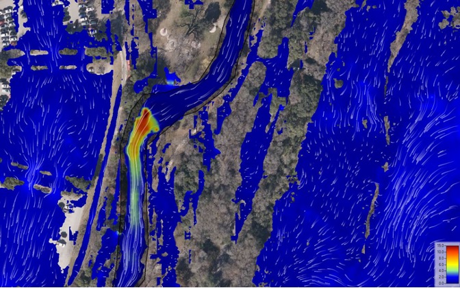
Example of hydraulic model simulations used to identify how the San Antonio River behaves during a flood event
The next time you find yourself curious about your nearest stream, explore the San Antonio River Authority’s Learning Modules. Here, you can see the fruits of the hard work of the River Authority engineering team as you discover the many wonders of the basin and delve into how our river system and floodplain work.


