The San Antonio River Basin is made up of a complex arrangement of creeks and rivers and their corresponding watersheds. The San Antonio River Authority (River Authority) developed the San Antonio River Basin Report Card in 2020 from the agency’s drive to harmonize the needs of people and nature through our stewardship of rivers and land. The main purpose of the San Antonio River Basin Report Card is to shine a light on the healthy and the unhealthy aspects of the basin to educate the public and serve as a catalyst for community discussions that lead to individual choices and public policy decisions, actions, and investments that support a sustainable San Antonio River Basin.
The 2021 San Antonio River Basin Report Card was released on the last weekend in September to correspond with World Rivers Day. The overall grade for the 2021 San Antonio River Basin Report Card is a “B,” which is the same as it was last year. This grade is the average of twelve individual indicator grades. With each annual basin report card, the grades for the indicators will show trends clearly demonstrating where progress is being made and where improvements are still needed. Each month, we will be highlighting a specific indicator and its grade to help provide insight and to share how you can help by joining us in our efforts towards improving the health of area creeks and rivers.
Basin Report Card 2021 Highlights – Park Usage
Over the past decade, the River Authority has added nature-based recreational activities throughout the basin including hike and bike trails, paddling trails, picnic and camping areas, playgrounds, fishing, birdwatching, and even disc golf courses. These river-based recreational resources have attracted thousands of users to bask in the beauty and enjoyment of nature.
For the 2021 San Antonio River Basin Report Card, the grade for park usage was an “A+.” This grade was calculated by using the total park usage for this fiscal year (July 1, 2020 – June 30, 2021) and dividing that number by park usage data from previous fiscal years, then multiply by 100 to get the final score. All the individual park scores related to usage of parks operated and maintained by the River Authority are averaged together for one grade and a second grade is created for all the individual park scores related to usage of parks located along creeks and rivers throughout the basin which are operated and maintained by other governments or entities. These two grades are then averaged together to determine the final overall grade for this metric. Essentially, this grade is a trend analysis for park usage with the basic assumption being that maintaining or increasing the amount of park usage is positive (i.e., will get a higher grade) and a decreasing amount of park usage is negative (i.e., will get a lower grade).
Park usage is up once again during Fiscal Year 2020-21 as compared with park usage data from previous fiscal years. It is believed that they ongoing COVID-19 pandemic has once again impacted the park usage numbers as citizens remain eager to get outside and utilize the nature-based and cultural park resources throughout the San Antonio River Basin. Overall, the data shows a growth in park usage for both River Authority and non-River Authority parks as, collectively, more than 243,000 park users were recorded above last fiscal year’s total park usage figure. Of the 16 individual park usage scores, 11 recorded an increase in usage over previous fiscal years and 5 recorded a decrease.
How can I get involved?
The San Antonio River Authority invites you to visit and enjoy the more than 500 acres of parks, which include more than 28 miles of hike and bike trails, and over 60 miles of paddling trails along the San Antonio River’s 240-mile course! Our dedicated park programming and events staff are responsible for creating unique and engaging opportunities so that our constituents can safely enjoy our parks and trails and forge meaningful connections to our creeks and rivers. We invite to visit our events page to stay up to date with the latest info and join the fun!
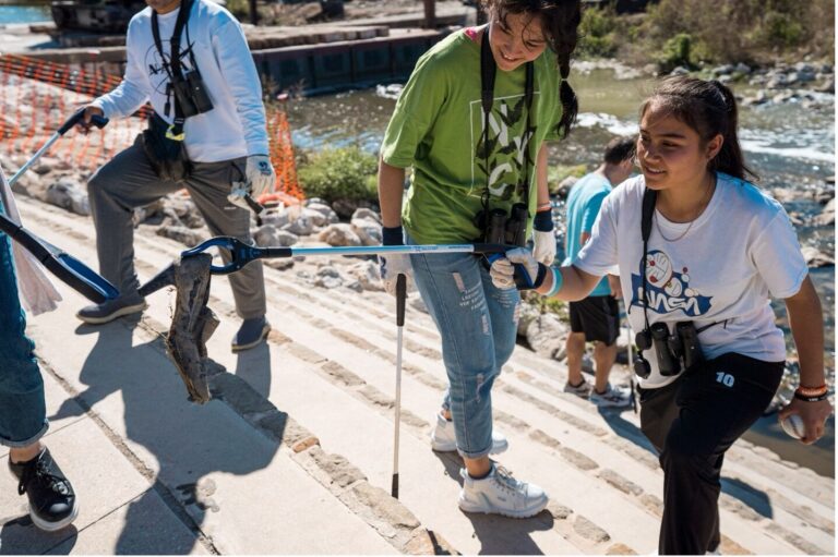
Another way to get involved is to do your part to protect and preserve our area creeks and rivers. You can help stop the spread of invasive species like Apple snails by not dumping your fish tank in area waterways. To proactively address the threats to creeks and rivers from litter, floatable trash, and illegal dumping throughout the San Antonio River Basin, the River Authority has recently launched a new public outreach initiative related to trash. The public can visit the River Authority’s trash initiative webpage to take our “Don’t Let Litter Trash Your River” pledge, learn how to get engaged by using the Litterati app, help support the initiative by using the social media tool kit, and obtain resources for individuals and community organizations who would like to become a River Warrior volunteer or organize cleanup events to help with our efforts.
Together, we can achieve and maintain good grades in the annual San Antonio River Basin Report Card by focusing our collective community attention on improving areas that are scoring low. We invite you to view the full report card and learn more about the indicators, including what you can do to help next year’s overall grade improve!