About Us

About The Authority

San Antonio River Authority

In 1917, the voters of Texas, recognizing the necessity of developing and conserving the State’s water resources and inspired by devastating floods of 1913 and 1914, passed a Constitutional amendment allowing the Legislature to create special purpose political subdivisions of the State to serve regional areas, generally coincidental with river basins and to be generally known as river authorities.

San Antonio River Authority, created in 1937, is one of many such active river authorities in the State of Texas. Its jurisdiction covers 3,658 square miles—all of Bexar, Wilson, Karnes and Goliad Counties.

Vision

Inspiring Actions for Healthy Creeks and Rivers.

Mission

Committed to Safe, Clean, Enjoyable Creeks and Rivers.

Our Leadership

Governance

A 12-member Board of Directors governs the San Antonio River Authority (River Authority). Six directors are elected from Bexar County and two are elected from each of the three other counties with each elected member serving six years. Policies established by the Board are executed by the management organization under the direction of a General Manager appointed by the Board.

Taxing Authority

The San Antonio River Authority has the statutory authority to impose an ad valorem tax for use in planning, operations and maintenance activities only. Its tax is statutorily limited to two cents per $100 of assessed property valuation. The adopted ad valorem tax rate is $0.01787 (1.787 cents) per $100 assessed property valuation. The average annual tax is $55.13. The adopted FY 2024-2025 budget is $373.8 million.

Our Culture

The River Authority's Core Values

Accountability

Excellence

Open & Direct Communication

Team Work & Collaboration

Agency Goals

Key Enabling Activities

Alerts

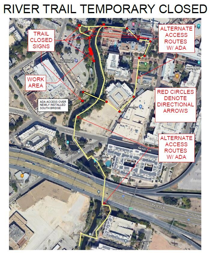
Trail Closure: Museum Reach at Pearl

* Trail temporarily closed from 2/3/2025 until 4/25/2025. * For southbound pedestrian traffic, please exit the river and utilize the Hotel Emma bridge to gain access to the east side river trail. Access to the east side river trail via the elevator or stairs. * For northbound pedestrian traffic, please exit the river trail at the south bridge to gain access to the east side river trail. Continue north through Pearl towards Hotel Emma. The west & east side river trail accessible via the Hotel Emma bridge. North Bridge West Landing & Stairs Trail Closure Map  

Goliad Paddling Trail Alert

NOTICE: HWY 59 Landing Site Closed Due to TxDOT construction on the HWY 59 Bridge, the HWY 59 landing site is closed until further notice. However, the Goliad Paddling Trail remains open, and paddlers can still access the river at the Riverdale, Ferry Street, and Goliad State Park landings. Please plan accordingly and check back for updates.

SASPAMCO Paddling Trail Temporarily Closed

Staff have removed two large log jams just downstream of Helton Nature Park, keeping the southern portion of the SASPAMCO Paddling Trail temporarily closed. Staff are working to contact adjacent landowners to support a land-based removal solution.

SASPAMCO Paddling Trail

The SASPAMCO paddling trail is open from River Crossing Park to Helton Nature Park. *Please Note: Paddling Trail from Helton Nature Park to HWY 97 is still closed due to blockages. 

River Reach Newsletter and Blog Signup

River Reach is offered as a printed, physical mailing to your residence or business. The Blog is a weekly electronic email with news and updates in order to be more environmentally conscious. Please fill out the form below and indicate your preferred method of delivery.

By submitting this form, you are consenting to receive marketing materials from: San Antonio River Authority, 100 East Guenther St., San Antonio, TX, 78204, US. You can revoke your consent to receive emails at any time by using the SafeUnsubscribe® link, found at the bottom of every email. Emails are serviced by Constant Contact. This site is protected by reCAPTCHA and the Google Privacy Policy and Terms of Service apply.